
I lucked out by picking an expensive cabin last night. It was next door to a restaurant. I had pasta with grilled chicken, corn, cornbread, a salad, and two Polygamy Porters. The food was excellent. My body was so happy with me.
This morning I returned to the place for breakfast. A huge omelet, mass quantities of hash browns, toast, and coffee. Yummie.
Locked and loaded I lit out at 8:30 headed west. More rocks. A few abandoned ancient buildings made of the red sandstone that seems to be everywhere.

After 20 miles the road entered Capitol Reef National Park. It was boffo but not entirely distinguishable from what I had been riding through since Blanding.
Perhaps because it’s a National Park, traffic picked up from next to nothing in Hanksville to rental RVs in pace lines.
(I have a heightened level of awareness because the RV renters don’t have any experience driving a tank and they, and other drivers, are distracted by the scenery. Thank god for rumble strips in the middle of the road and bicycle mirrors.)
I cane across this sign and had to stop. Did the sign person think the amazing views of the previous 50 miles were not up to par? Exactly how big a dolt do you need to be to figure this out for yourself?

Midway through the park, I came to the visitors center which was a beehive of activity. Signs said “Campground Full”. Uh oh.
I topped off a water bottle, and continued westward. Uphill. Despite a tailwind, the climb was a bit of a shock to the legs and lungs.
More rocks. Some petroglyphs. More RVs.
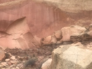
Do you see the petroglyphs of people?

Without the sign, you’d never guess you were in a National Park. The whole area is National Park-ish or, Park-y. Of course, the sign affords the opportunity for a park sign selfie.

I spent the next ten minutes taking pictures of people in front of the sign (and feeding mosquitoes).
Five miles beyond the visitors’ center I was out of the park and in the park-ish part. Up and down and around buttes. I finally saw two resort motels. One had horses and llamas. The other had a pizza joint. Since I can’t eat a llama or a horse, I voted for the pizza joint.

Thankfully they had a vacancy.
Talking with some other motel guests, I learned the porch might provide some good sky watching tonight here outside Torrey, Utah.
Tomorrow is the 8,900 foot mountain pass. (I’m at 6,600 feet.) Then a descent to toward Escalante.
More pictures can be found on Instagram under @rootchopper.
Miles today: 45
Tour miles: 1,986.5
Top speed: 34.2
